Saskatchewan
"From Many Peoples Strength"
Saskatchewan is home to Canada's only training academy for Royal Canadian Mounted Police recruits, located in Regina. Saskatchewan is the site of North America's oldest bird sanctuary, establised in 1887 at Last Mountain Lake.
The City of Estevan in southeast of Saskatchewan is Canada's sunshine capital, averaging 2,540 sinshine filled hours each year.
Saskatchewan produces over 54% of the wheat grown in Canada.
Saskatchewan has more road surfaces than any other province in Canada, with a total of 150,000 miles.
Saskatchewan is the only province with entirely man-made boundaries.
Population: 990,212 estimate as of 2007 (Source: Statistics Canada)0
Capital City: Regina (metropolitan area) - population 194,971
Largest City: Saskatoon (metropolitan area) - populaltion 233,923
Time Zone: Central Standard Time year round.
Highest elevation: Cypress Hills - 4,566 feet above sea level.
Major River Systems: The North Saskatchewan, South Saskatchewan, Assiniboine, Churchill Rivers all flow into Hudson Bay
Principle Industry: Mining, manufacturing, tourism, agriculture
Origin of Name: From the Plains Indian word, "kisiskatchewan" meaning "the river that flows swiftly", a referecnce to the area's major rivers
Land and Geography: More than a quarter million square miles in size. Contrary to popular belief, one half the province is covered by forest, one third by farmland and one-eighth by fresh water.
Location: Saskatchewan is located in the heart of North America. To the east and west are the Canadian provinces of Manitoba and Alberta. To the south it borders the American states of Montana and North Dakota. To the north are Canada's Northwest Territories and Nunavut.
Heritage: Saskatchewan is culturally diverse, with people of Aboriginal, European, Russian, Ukrainian, Polish, Scandinavian and British heritage.
Saskatchewan Cities: Saskatchewan is home to 13 cities: Estevan, Humboldt, Lloydminster, Melfort, Melville, Moose Jaw, North Battleford, Prince Albert, Regina, Saskatoon, Swift Current, Weyburn, Yorktown
for more photos: www.ethanmeleg.com/saskatchewan.htm
Flag
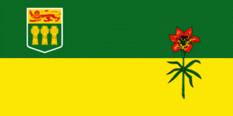
Adopted in 1969, the flag of Saskatchewan is divided horizontally into two halves. The upper green half represents the forest areas of the north while the lower golden half represents the prairie grain fields of the southern regions. The Armorial Bearings are placed in the upper left near the mast while a Western Red Lily, the floral emblem of Saskatchewan, spans the two coloured halves of the flag on the right. The red Royal Lion on the gold background of the shield represents Saskatchewan's links to England while the 3 sheaves of grain on the green background represent Saskatchewan's agricultural contribution to Canada and to the world.
www3.sympatico.ca/goweezer/canada/flagSASK.htm
Some Facts...
- Sask. -located in the prairie region of Canada
-Alberta to the west, Manitoba to the east
-U.S. is south and Northwest Territories are north
-Regina, the capital city, is the home of the R.C.M.P.
-flower - Western Red Lily, tree - White Birch, bird - Sharp-tailed Grouse
-motto: "From many peoples strength"
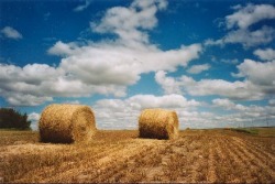
Picture:
Summer on the Saskatchewan prairie.
flickr.com/photos/7754846@N06/1042364387/
Land and Water
-half is forest, one-third is farmland
-over 100,000 lakes, rivers, marshes
-southern part is mainly flat land
-Athabasca Provincial Park has sand dunes 30 m. high
-main rivers: Assiniboine, North and South Saskatchewan and Churchill
-two largest cities are Regina ( the capital ) and Saskatoon
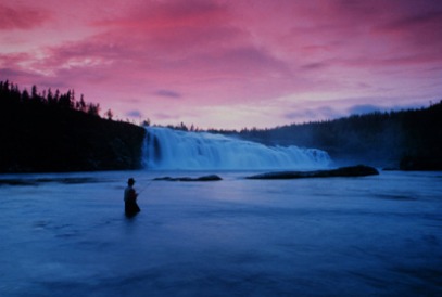
Picture: Hunt Falls, in northwest Saskatchewan by Douglas Walker
photo courtesty Tourism Saskatchewan
www.virtualsk.com/current_issue/lefty.html
The People
-First people : Chipewyan (north) , Assiniboine (east), Blackfoot (west) and Cree
-Metis (of mixed European and Aboriginal descent) were among the first settlers.
-people came from Germany, Ukraine, Scandinavia, Poland, Russia, Britain, France
-population 990,930 (January, 2006)
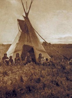
Chipewyan berry-picking party, photograph by Edward S. Curtis.
Library of Congress, Washington, D.C.
www.britannica.com/EBchecked/topic-art/113112...
People and Places
-W.O. MITCHELL (born in Weyburn) wrote about prairie life in his book "Who Has Seen the Wind".
-JEANNE SAUVE (born in Prud'homme) was the first woman to be a governor-general of Canada.
-GORDIE HOWE, one of the greatest hockey players of the NHL was born in Floral, Sask.
-BUFFY SAINTE-MARIE, a well-known singer/songwriter, was born in Saskatchewan.
-Tunnels of Moose Jaw : underground passageways used by the Chinese, gangsters and bootleggers.
-Big Muddy Badlands : unusual land formations and petroglyphs
-Great Sand Hills : dunes of sand on the prairies
-Wanuskewin Heritage Park: archaeological digs provide information about the Indians of the Northern Plains
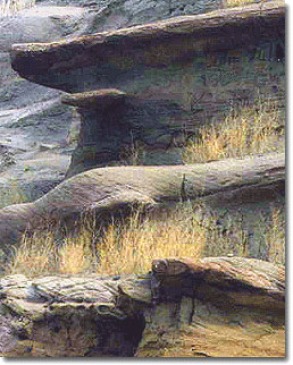
Picture: Erosion sculpts character into the Big Muddy Badlands of southern Saskatchewan.
www.virtualsk.com/current_issue/ought3.html
Economy
-produces 28 percent of Canada's grain
-grows over 54 percent of Canada's wheat crop
-crops include canola, rye, oats, barley, flaxseeds, wheat
-hogs and cattle are raised on farms and sold
-forestry in northern Saskatchewan
-rich in minerals (potash, uranium, coal, oil and natural gas)
-leading exporter of potash ( fertilizer )
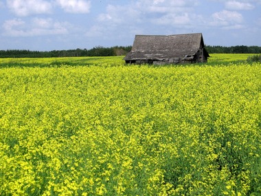
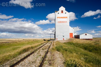
Picture: Grain elevator in prairie, southern Saskatchewan
by Ethan Meleg
www.ethanmeleg.com/saskatchewan.htm
History
-earliest explorer - Henry Kelsey (1690)
-Samuel Hearne built trading posts
-trappers and fur traders arrived
-forts were built to maintain law and order
-settlers were encouraged to come for free farmland
-railroad was built across the southern part of the province
-became a province in 1905 with Regina as the capital
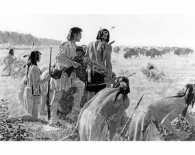
Picture: An imaginative reconstruction of young Henry Kelsey first encountering buffalo on the Plains, 1691, exploring for the Hudson's Bay Company.
www.canadianheritage.org/reproductions/10116.htm
