Yukon Territory
The Beautiful Land
Located in the Canadian Cordillera physiographic region.
A total land mass of 483,610 square kilometers (about the size of Spain).
It has 430 kilometers of shoreline along the Beaufort Sea, which is home ot the historically significant Herschel Island.
As of December 2007, Yukon's population is 32,714, of which about three-quarters live in the capital city of Whitehorse.
P
Located in the Canadian Cordillera physiographic region.
A total land mass of 483,610 square kilometers (about the size of Spain).
It has 430 kilometers of shoreline along the Beaufort Sea, which is home ot the historically significant Herschel Island.
As of December 2007, Yukon's population is 32,714, of which about three-quarters live in the capital city of Whitehorse.
Yukon is in the Canadian Cordillera, a series of mountain ranges and valleys that stretches along the Pacific coast of North America. The territory is separated from the Pacific coast by the Alaskan panhandle.
The broad Yukon Interior Plateau is in central Yukon, between the western Coastal Ranges, and the Selwyn and Ogilvie Mountains on the east. A tundra plain stretches along the Arctic coast.
The Arctic coastline stretches 200 kilometers along the Beaufort Sea. One of Yukon's Arctic islands is located five kilometers off teh north shore, Herschel Island.
Mount Logan is the highest point in Canada at 5,971 meters. It's located in the St. Elias mountains in southwest Yukon Territory. At least 20 other peaks in these ranges rise over 3,000 meters.
Watersheds:
The Yukon River is the second longest river in Canada and drains almost 2/3 of the territory. It runs 3,185 kilometers from northern British Columbia to the Bering Sea. The territory's largest lakes - Kluane, Teslin, Bennet and Laberg - are located near the headwaters of the Yukon River.
Other major rivers include:
The Alsek River flows throughout southwestern Yukon to the Gulf of Alaska.
The Liard River flows through southwestern Yukon into the Mackenzie River in the Northwest Territories.
The Peel River drains the Wernecke and Oglivie mountians in northeastern Yukon.
The Firth, Babbage and Blow Rivers flow through Yukon's North Slope to the Beaufort Sea.
Glaciers:
North and west-central Yukon were not covered by glaciers during the last Ice Age. Scientists say the ice-free corridor allowed animals and the ancestors of North American aboriginal peoples to migrate from Asia across the Beringia land bridge. Today the largest non-polar ice field in the world is located in the St. Elias mountain ranges. The icefield, believed to be 700 meters deep in the heart of the mountains, sends glacial fingers as long as 30 km down valleys between peaks.
Climate:
Yukon has a sub-arctic climate. Winters are cold with long dark nights. Summers are mild with long sunny days. Above the Arctic Circle, the sun doesn't set on June 21st and doesn't rise on December 21st. Climate influences vary across the territory. Cold air masses from the Arctic dominate the northern part of Yukon. Warmer air masses from the North Pacific moderate temperatures in southwestern Yukon. However, most of the Pacific Ocean's moisture and warmth doesn't reach central Yukon because of the St. Elias and coastal mountains. The territory is relatively dry throughout the year. Average January temperatures range from -20 C to -32 C. An extreme low of -62.8 C was recorded at Snag in the western Yukon in February 1947. The average July temperature is about 14 C, although summer days can reach upwards of 32 C.
Plants:
Yukon's vegetation is classified as sub-arctic and alpine. Boreal forests cover 57 percent of the territory. White spruce, black spruce, lodgepole pine, Alpine fir, aspen and balsam poplar are the most common tree species. There are more than 200 species of wildflowers in Yukon. They include anemones, yellow potentilla, monkshood, arctic poppy, harebell, wild rose, lupines, lousewort, wintergreen (pyrola) and heardtongue (penstemon). Tall magenta fireweed is one of the most common flowers. Alpine areas are dotted with moss campions, wild forget-me-nots, and mountain avens. Orchids include the white bog orchid, ladies tresses and the round leaf orchid.
Mammals:
Yukon is home to seven species of large mammals including North America's largest population of grizzly bears and Dall sheep. The grizzly bear is a vulnerable species. Grizzlies range over the whole territory preferring open, alpine areas. One of the highest concentrations of grizzlies in North America is in Kluane National Park.
Black bears are also found in Yukon. They are mostly seen at lower elevations and in forested areas.
The polar bear is seen occasionally along the Arctic coast and in the area of Herschel Island.
About 18,000 Dall sheep live in dry, grassy alpine areas. The largest populations are in the Kluane ranges, Coast anges and Western Yukon. About 4,000 darker colored Stone sheep are also found in Yukon.
The Porcupine caribou herd is one of the last migratory herds of barren ground caribou in the world. This herd - about 180,000 animals - travel along the northern slope. The herd travels more than 750 kilometers annually from its calving grounds on the Arctic coast to wintering grounds in the southern Oglivie, Wernecke and Richardson Mountains.
Woodland Caribou are found in the territory in smaller numbers. Several thousand mountain caribou live in smaller herds in the southern Yukon and in the Polly Mountains, the Burwash Uplands, around Watson Lake and in the Carcross-Tagish area.
Wolves can be found in the same habitats as moose and caribou, traveling with herds from winter to summer ranges. Yukon has a healthey population of wolves.
Moose are found throughout the Yukon. They are mostly seen in sub-alpine shrub, lowland bogs, burn areas and floodplains.
Elk, musox and mule deer are also found in small numbers in Yukon. Elk and muskox were reintroduced to the territory after extermination in the 1800s. Muskox are seen only on the tundra along the northern coast. Elk are found in the Takhini River burn area west of Whitehorse and in the Silton Ranges of southern Yukon. Mule deer can also be found in southern Yukon and north as far as thee Petty and Ross rivers.
Fourteen species of smaller furbearers live in Yukon. They include lynx, marten, muskrat, beaver, wolverine, arctic fox, coloured fox, coyote, mink and fisher.
Birds:
Approximately 214 species of birds can be found in Yukon. There are several major migration routes for waterfowl through southern and central Yukon. Trumpeter and tundra swans, snow and Brant geese, northern pintail, common elder, oldsquaw, greater and lesser scaup, and sandhill cranes travel to Yukon annually. At least 21 species of hawks and owls can be seen in Yukon. Bald eagles and gold eagles are common. There are also healthy populations of gyrfalcons and peregrine falcons. Seven species of grouse and ptarmigan live here year round.
Fish:
More than 200,000 fish are caught annually in Yukon by residents and visiting sports anglers. Popular species include lake trout, arctic grayling, northern pike and dolly varden. Commercial fishermen prefer chinook, coho and chum salmon, and whitefish.
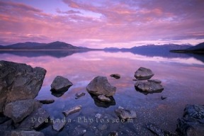
Pictured above: a brilliant sunset over Kluane Lake in the Yukon Territory, Canada.
by Rolf Hicker Photography
www.canada-photos.com/yukon-territory-sunset-...
Some Facts...
- Y.T. -one of three territories in Canada
-the smallest territory
-east - Northwest Territories, south - British Columbia
-north - Arctic Ocean, west - the state of Alaska
-capital city is Whitehorse
-flower - Fireweed, bird - Common Raven, tree - Sub-alpine Fir.
-name : from the Native word "Yu-kun-ah" meaning Great River
-Known as "the beautiful land"
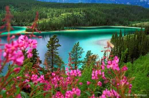
Picture: Emerald Lake, Yukon Territory
www.wildnatureimages.com/EmeraldLakePhotos.htm
Flag
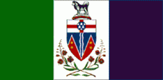
The flag of the Yukon Territory was officially adopted in 1967.
It features the entire coat of arms adopted in 1956. The green panel is symbolic of the indigenous Taiga forests; the white panel is symbolic of winter snows, and the blue symbolic of the northern waters.
Land and Water
-many rivers, lakes and streams in the Yukon
-main rivers : the Klondike, Peel, Pelly, Stewart, Porcupine and Yukon
-The Yukon River is 3,520 km (2,200 miles) long.
-part of the land is "tundra" : rocky, moss, tough grasses, small willow shrubs grow
-soil is frozen so growing crops is difficult
-part of the land is covered with forests
-There are three national parks in the Yukon.
-Mount Logan, the highest mountain in Canada (6000 m.) is in Kluane National Park.
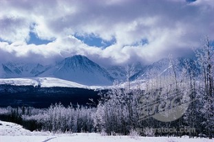
Picture: Snow covered landscape of Kluane National Park, Yukon Territory, Canada © Superstock, Inc./ SuperStock
www.superstock.com/stock-photos-images/77-2771
The People
-population about 31,587 (2005)
-Over 70 percent live in Whitehorse, the capital city (23,511 people).
-Some other communities are Dawson City (1,827); Watson Lake (1,544); Haines Junction (824); Carcross (446); Carmacks (408) populations as of Dec/05
-People have come from other parts of Canada to live in the Yukon.
-About 24 percent of the people are Aboriginal (2001 census).
-There are fourteen First Nations, speaking eight different languages.
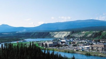
Picture: Whitehorse-the capital of the Yukon Territory
www.ideamerge.com/.../canada/locations_2.html
People and Places
-Audrey McLaughin was a member of parliament for the Yukon. She was the first woman to lead a national party (the N.D.P.)
-Robert W. Service (1874-1958) was "the poet of the Yukon". He wrote poems about life during the Klondike Gold Rush.
-Ted Harrison, an English artist, painted landscapes of the Yukon.
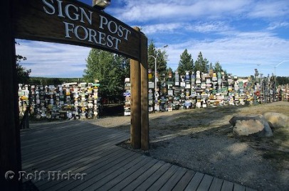
-Watson Lake is (near the southern border) the site of Signpost Forest.
There are over 30,000 signs from cities and towns around the world
-Dawson City has many historic places to see.
Photo of Sign Post Forest in Watson Lake in the Yukon Territory, Canada.
by Rolf Hicker
www.hickerphoto.com/sign-post-forest-watson-l...
Resources
-People visit the Yukon to hike, raft, camp, rock climb, fish, see wildlife, and hunt.
-Tourism provides many jobs for people.
-The largest industry is mining (gold, lead, zinc and silver).
-They are drilling for oil in the Beaufort Sea.
-Factories package fish (grayling, northern pike, lake and rainbow trout, salmon, whitefish, and arctic char).
-Beaver, lynx, wolverine, muskrat, marten and fox are trapped and the furs are sold.
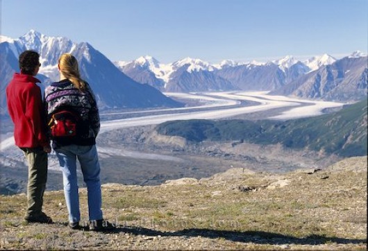
Picture: Picture of tourists looking out over the Kaskawulsh Glacier in Kluane National Park in the Yukon, Canada.
photo by Rolf Hicker
www.canada-photos.com/kaskawulsh-glacier-yuko...
History
-Aboriginal people may have migrated from Asia across a Bering Sea land bridge.
-They hunted, fished and trapped to survive.
-In 1840 Britsh fur trader and explorer Robert Campbell arrived.
-Forts were built so the Hudson's Bay Company could trade for furs with the trappers.
-Klondike Gold Rush in 1896 brought many people to the Yukon.
-Thousands of prospectors formed a "tent city" called Dawson.
-In 1898 the area became Canada's second territory.
-Dawson was the capital until 1951.
-By 1899 the gold was almost gone so people left the Yukon.
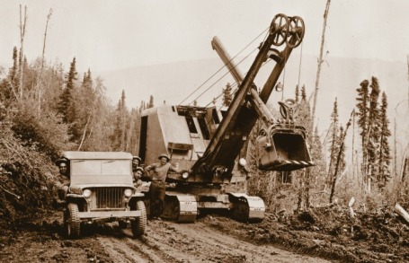
-Building of the Alaska highway in 1942 brought hundreds of workers.
-The highway (1,520 miles or 2,446 km) was constructed in eight months and twelve days.
-Whitehorse replaced Dawson as the capital.
-Canadian government opened the Dempster Highway in 1979.
-It is an all-weather road that crosses the Arctic Circle.
Picture: Workers cut their way through the forest to carve out the Alaskan highway back in 1942.
www.engineering.ualberta.ca/uofaengineer/arti...
