Manitoba
"Land of 100,000 Lakes"
Manitoba is the easternmost of the three Prairie Provinces. Comparatively level, Manitoba generally ranges from 490 ft/150 m to 98 ft/300 m above sea level. Baldy Mountain is Manitoba's highest point, at 2727 ft/832/m. Agricultural land llies in a triangle, bordering Saskatchewan and the U.s. cutting diagonally across lake Winnipeg. The northern 3/5 of Manitoba is a Precambrian Shield. In northernmost Manitoba lies tundra and permafrost (permanently frozen subsoil). All waters in Manitoba flow to the Hudson Bay. Before settlement, a large area of southern Manitoba was flood plain or swamp. An extensive system of drainage ditches had to be constructed throughout south central Manitoba to make the region suitable for cultivation.
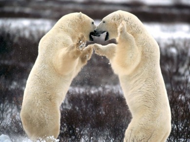
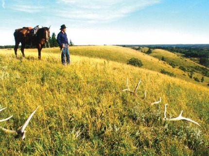
Canada's only sub-Arctic seaport, the town of Churchill has made its international reputation as the Polar Bear Capital of the World. This community of hardy northerners sits on the bears' annual fall migratory route back to Hudson Bay from the Arctic tundra. But Churchill boasts even more natural wonders. Whether it's dazzling Northern Lights or Aurora Borealis, the aerial drama of migratory birds overhead, or deep, rich sumer and fall colours of tundra mosses and wildflowers, or thousands of curious beluga whales in the Churchill River, Churchill is filled with life.
From late June, until mid August, thousands of beluga whales or "sea canaries" named for their underwater vocaliing - feed in the Seal and Churchill rivers emptying into Hudson Bay. Some four operators enable visitors to listen in on the belugas, and advenurous travelers can kayak or snorkel with these friendly, curious sea mammals.
At night under clear winter skies, the highest intensity of aurora activity in the Arctic happens over thei regions, so chances are good for a genuinely dramatic display of Aurora Borealis - dancing "light curtains" glowing green, red, yellow and white.
The sub-Arctic summer landscape offers up surprising bursts of colour. More than 400 native plants species can be found here, from mosses and lichens to bearberries and yellow willows. Look for the delicate beauty of dozens of varieties of wildflowers, and keep an eye out for woodland caribou and nesting swans.
The best time of year to catch sight of polar bears is in October and November when these massive beasts move from their summer habitat on the tundra back to seal-hunting territory - the pack ice that forms every winter over the Hudson Bay.
In spring and fall, birders flock here to watch avian migrations as northern species, including bountiful snow and Canada geese, head north or south. Tundra and taiga provide habitat for more than 200 species of native birds, including a large variety of hawks and falcons like the gyrfalcon and peregrine falcon. Snowy owls are common here, as are tundra swans, terns, and gulls. Harlequin ducks and the rare Ross' bull are less commonly seen, but when they are, it's the sight of a lifetime for the avid birder.
Pictured Above: Polar Bears in Churchill, Manitoba
www.firstpeople.us/pictures/bear/Sparring-Pol...
Flag
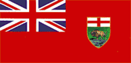
Act of Legislature assented to May 11, 1965
Queen Elizabeth II's approval of use of Royal Union flag given on August 27, 1965
Flag raised on May 12, 1966
www.canadianheritage.gc.ca/.../atc-ac/mb_e.cfm
Land and Water
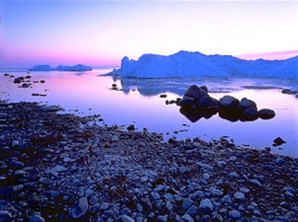
-Manitoba is known as the land of 100,000 lakes.
-Lake Winnipeg, Lake Winnipegosis and Lake Manitoba are three large lakes.
-The three largest rivers are the Churchill River, Nelson River, and Hayes River.
-The three rivers flow into Hudson Bay in northern Manitoba.
-Forests (pine, hemlock and birch) cover northern Manitoba.
Pictured to the Right:
Lake Winnipeg, Manitoba, Canada
Brian Sytnyk/Masterfile
www.britannica.com/EBchecked/topic-art/362369...
Places and People
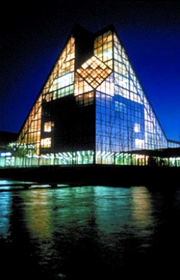
-The Royal Canadian Mint ( where coins are made ) is in Winnipeg.
-The Viking at Gimli - a giant statue honoring the ancestors of the Icelandic people.
-Churchill in northern Manitoba is "the polar bear capital of the world". Polar bears make their dens near the town.
-Nellie McClung (1873-1951) - fought for the rights of women
-Jackson Beardy (1944-1984) - Cree artist
Pictured to the Left: Royal Canadian Mint at night
http://www.winnipeg.worldweb.com/Winnipeg/FeaturesReviews/LocalAttractions//8-146862.html
Some Facts...
- Man.-Manitoba is one of the three prairie provinces in Canada.
-It is located in the center of Canada.
-Ontario is to the east and Saskatchewan to the west.
-Nunavut is north and the United States is south.
-"Manitoba" is a Cree name meaning "the place where the spirit (manitou) speaks."
-capital city - Winnipeg.
-second-largest city - Brandon.
-flower-Prairie Crocus , tree-White Spruce, bird-Great Gray Owl
-motto-"Glorious and Free" THE PEOPLE -Manitoba is the home of over a million people.(1,177.600 in 2005)
-Winnipeg is the largest city. About 706,900 people live there.
-Manitoba is home to many Metis and native peoples.
-People came to Manitoba from Britain, Europe, Europe, East and Southeast Asia.
-Some large ethic groups : Ukranian, Mennonite and Icelandic. HISTORY-The first people to live in Manitoba: Assiniboine, Cree, Saulteaux, Chepewyan, Ojibwa.
-They followed herds of bison and caribou.
-Early explorers arrived through Hudson Bay in northern Manitoba.
-Hudson's Bay Company (created in 1670) set up fur-trading posts along the rivers.
-The first French settlement was Fort Rouge.
-The first British settlement was Red River.
-Louis Riel (1844-1885) was an influential Metis leader.
-Riel and his people were concerned about the settlers taking over their land.
-He is often called the Father of Manitoba.
-Manitoba became Canada's fifth province in 1870.
-The railway brought thousands of settlers from eastern Canada and from all over the world.
Resources/Industries
-Manitoba lies in the area of Canada known as the Canadian Shield.
-Minerals and metals are found in the Canadian Shield.(nickel, gold, copper, zinc, cobalt, gypsum)
-Manitoba has petroleum (used to make gasoline).
-One-fourth of land is covered with forest.
-Hydro-electric power is an important industry.
-Manitoba sells hydro-electric power to other provinces and to the US.
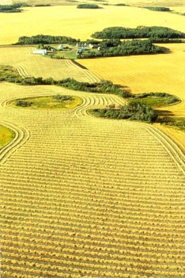
-There are different types of farming in southern Manitoba:
One-third of the farmland is used for growing wheat.
Mills make wheat into flour.
The wheat is sold to other countries.
Farmers also grow barley, oats, sunflowers, flax and canola.
These crops are made into cereal and oil products.
Dairy farms produce milk, cheese, yogurt and cream.
There are also livestock farms.
-Industries include manufacturing (farm equipment, buses, fashion, furniture), food processing, aerospace and transportation.
Pictured Above: Wheatfield in Manitoba
www.billcasselman.com/casselmania/mania_one.htm
